
GIS coverages of the border region encompassing southwestern New Mexico will play an important role in regional water management and planning. Bob Creel of the New Mexico Water Resources Research Institute (WRRI) will lead an effort that will employ an interdisciplinary team comprising a GIS technician and hydrology, geology and geochemistry investigators to map the region.
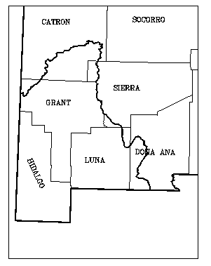
The project, partially funded by the U.S. Environmental Protection Agency, will concentrate on the border region of southwestern New Mexico including portions of Luna, Hidalgo, Grant and Catron counties in New Mexico (see study area map). This effort is in response to groundwater quality concerns, especially in light of the area’s total dependence on groundwater for drinking water.
The border region is one of the fastest growing population centers with over 3 million people projected by 2015. Groundwater levels in parts of the region have declined and projected water demand will put additional strain on the area’s scarce water resources. Local, state and federal agencies concur that a better understanding of shared transboundary water resources is needed. The environmental and economic impacts of the North American Free Trade Agreement have provided an additional impetus to monitoring the area’s natural resources.
Information on the region’s water quality and quantity has been gathered by numerous entities over the years for a variety of purposes. The data exist in different formats, differ in degree of resolution and data quality, and often are not readily accessible. The need for aggregation and analysis of existing data is apparent.
The project has six main objectives. First, existing well data from various entities will be evaluated for accuracy and subsequently transposed into a common database format developed for international data transfer. Well data will be collected from sources including the U.S. Geological Survey, New Mexico Environment Department, and the Office of the New Mexico State Engineer. The well data will be incorporated into GIS format and presented on maps of the region.
Second, transboundary aquifers will be identified and characterized as to their lateral and vertical extent, saturated thickness, and volume of usable and marginal quality water in storage. Potential recharge zones will be identified and the potential for contamination will be assessed. Investigators will digitize and map the surface extent of the aquifers and other adjacent and/or contributing groundwater aquifers into Arc/Info GIS coverages.
Third, existing groundwater quality analyses from federal, state and municipal agencies will be compiled and evaluated for accuracy. Again, this data will be transferred to a common database format. Data on concentrations of dissolved constituents including major cations and anions and other selected trace elements will be compared. The chemical quality of surface and groundwater from adjacent aquifers will be studied for potential interaction. Aquifer susceptibility to nonpoint and point source contamination will be determined. The DRASTIC model will be utilized to produce a natural sensitivity index/map of the aquifers. All existing data will be evaluated for its suitability for groundwater models using a GIS-based analysis to identify areas of weak coverage. A collection/monitoring program will be recommended.
Fourth, the hydrologic interaction of surface and groundwater will be studied. Depth to groundwater and direction of groundwater flow will be determined for each aquifer. Flow models simulating potential pathways for groundwater traverse will be developed. Interaction between aquifers and rivers will be determined along with the potential for transboundary subsurface groundwater flow. Existing river loss and gain studies will be examined to evaluate the groundwater flow direction and the loss and gain of the rivers due to interaction with the surrounding aquifer.
Fifth, pumpage data by type of user (irrigation, municipal, industrial, domestic, and livestock) will be collected and quantified. Pumpage effects on water levels and water quality will be estimated by reviewing the historical record of observation wells. Existing aquifer simulation computer models will be reviewed and recommendations will be made for additional modeling efforts.
Finally, the New Mexico WRRI will coordinate with the International Boundary and Water Commission , U.S. Section, for any data exchange, review and evaluation. A binational data report of officially exchanged data will be prepared. The report will include electronic media database tables, GIS coverages for each aquifer, and corresponding attribute tables, maps, and graphics to illustrate the characteristics of the studied aquifers. A final report to EPA will incorporate all data and provide conclusions and recommendations.
The project commenced in September 1997 and will conclude in 1998. In addition to Bob Creel of the New Mexico WRRI, John Kennedy, GIS coordinator also from the WRRI, Marta Remmenga from New Mexico State University’s Statistics Center, Barry Hibbs, a geologist/geochemist from Cal State, Los Angeles, and John Hawley, retired, from the New Mexico Bureau of Mines and Mineral Resources will participate on the study team.